►
ALPACA is specialist in personalized trek in Nepal.
Each trek is adaptable according to your wishes.
►
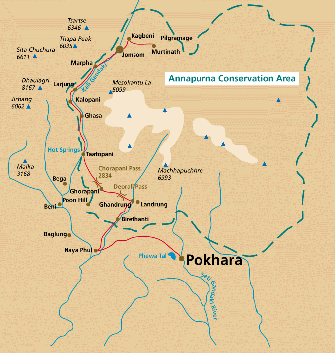
KALI GANDAKI TREK: 16 days
One of the most popular and short trek in Annapurna Region is attracting the maximum numbers tourist in totality. The trek is not tough, but people have to be quite “fit”. The another major attraction of this trek is of variation of culture and landscape in every days of your trip. You witness green, vegetation to landscape of dry land in the short span of this trip. The villages of local Gurung & Magars to Tibetan influenced hamlets are seen during the trek.
Grading of Trek : Moderate
Type of Trek : Lodge/ Tea House
Highest Elevation : 3500m (Jharkot)
Highest point accommodation : 3650 meters (Muktinath)
Best Time : March-April/ Oct-November-December
The Cost: Contact-us.
 Service includes:
airport transfer, 4 nights in Kathmandu hotel in BB basis, 2 nights in Pokhara hotel in BB, 09 days trek in lodge basis, 3 meals & accommodation in the available lodges during the trek, national park fees, flight fare for Ktm- Pokhara/ Jom-Pkr-Ktm, one guide, one porter for 2 members, daily wages and meal and accommodation of guide and porter, one porter is allowed to carry maximum of 30 kg of total weight, insurance of guide & porter,
full day sightseeing with English speaking guide with all entrance fees, one fare well dinner in Ktm.
Service includes:
airport transfer, 4 nights in Kathmandu hotel in BB basis, 2 nights in Pokhara hotel in BB, 09 days trek in lodge basis, 3 meals & accommodation in the available lodges during the trek, national park fees, flight fare for Ktm- Pokhara/ Jom-Pkr-Ktm, one guide, one porter for 2 members, daily wages and meal and accommodation of guide and porter, one porter is allowed to carry maximum of 30 kg of total weight, insurance of guide & porter,
full day sightseeing with English speaking guide with all entrance fees, one fare well dinner in Ktm.
Service Excludes: lunch/dinner at Pokhara and Kathmandu, laundry, telephone calls, emergency evacuation if required, donation, tips, domestic airport tax, and all personal nature expenses.
Itinerary:
Day 01 Arrival at Kathmandu (1350m), transfer to hotel.
Day 02 Around 9.30 AM in the morning there will be formalities of meeting the guide and brief information of the tour of the day. We start the tour for discovering the extraordinary city. The program will be:
Bhaktapur Durbar Square monuments with their wooden pagoda-temples, the
Bodnath or Swayambhunath’s Buddhist sanctuaries and Pashupatinath, a holy
Hindu temple where the cremations process of Hindu religion takes place, and, including many temples spread about along the crowded and busy streets of the antique city.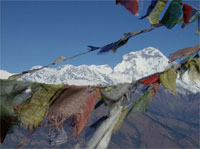
Day 03 Ktm-Pokhara (800 m)-Birethanti (1025m): After breakfast, get prepared for the last time of your luggage before getting transferred to domestic airport and fly to Pokhara, about 25 minutes. At the Pokhara airport, the trekking staffs will meet you and take you to the place where you can have lunch and later transferred by car to Nayapool, about an hour drive from Pokhara. Today’s walk will be very short, about 45 minutes reaching to Birethenti, large village with stone paved. We stop here for the day.
Day 04 Birethanti- Tirkhedhunga(1540 m): Start climbing up along the left bank of Bhurundi Khola from Birethanti, pass two rocky areas and crossing small suspension bridge. Now pass by small watermill to a steady climb along a stone wall to Sudame. We now leave the river Bhuruangdi and ascent along the upper edge of the terraced fields of Hile (1510 m). After walking 15 minutes you reach to Tierkhedhunga where few lodges are there, our stop for the night. 3.30 hours walk.
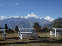
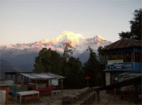
Day 05 Tirkhedhunga-Ghorepani (2750 m): After crossing Tirkhedhunga Khola and Bhuramdi Khola on suspension bridge we start a steep ascent climb on a stone staircase where it is said there are more than 3300 steps in this staircase, and, later we come to Ulleri village, a large Magar village at 2080 m. Now the climb becomes gentler and walking through the pastures & fields we soon come to deep forest and climb up to Banthanti (2250 m), village. We leave the trail to forest and catch another trail crossing two streams and after short final climb we reach Nangathanti (2460 m), a Magar village. After Nangathanti the trail becomes dense, stone steps and you reach to 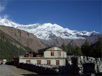 lower village of Ghorepani. After climbing of 15 minutes up you will come to upper village of Ghorepani (2750 m), the views of Dhaulagiri and Annapurna Himal can be seen from Ghorepani. If you climb an hour to Poon Hill you will have a wider range of Panoramic views of several mountains from east to west like Machhapuchare, Hiunchuli, Annapurna Siuth, annapurna I. On the left, NIlgiri HImal offers breath taking views and it looks like she is rising form the Kali Gandaki River. Our night stop at Ghorepani. 7 hours walk.
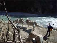
Day 06 Ghorepani-Tatopani (1190 m): Today you descent through the rhododendron forest along with small inn and pastures up to Chitre (2450 m). Now we take the west trail, and the trail come a cross to open wide region of extensive terracing, after a while it descends to Ghopte Kharka and to cross Ghar Khola on a small wooden bridge. We descend on to the left bank of Kali Gandaki. We still continue the trail and come to the suspension bridge. A short walk upstream along the Kali Gandaki, cross of suspension bridge and continuous walk for sometime on the right side of the bank of Tatopani (1190 m) which is divided to 3 small villages. We stop at Tatopani village where few good hotels & lodges are established to welcome you. 5.30 hours walk.
Day 07 Tatopani-Kalopani (2550m.): We take our trail by the right bank of Kali Gandaki with the view of Nilgiri Himal at the far, we come to left bank of another river Mirsiti Khola, we pass the small villages of Guite & Suke Bogarm and enter Dana, a Thakali village with big houses. After Dana the trail have several ups & down, river becomes narrow and we will see water fall and later we reach a village , Rukse Chahara. Now we come between two routes that leads to Ghasa. One follows the trail of steep on the right bank and through rocky trail via Kabre, the other one, wide open crossing the wooden bridge following the let bank of the river. We choose latter one, walking by the left bank of Kaligandaki, climbing up and going down to level path, cross the small suspension and later come to the village of Ghasa (2012 m). 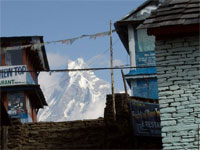 We leave the lower path of Ghasa and take the upper route of the village where we come across of pine grove more often and by the right bank of Kali Gandaki. We cross the suspension bridge over Lete Khola, walk up to the terrace with pine grove and later trail with the stone walls, this is Lete, from here, we can see Dahulagiri (8167 m). After Lete, we walk through the farm fields, there is Dhaulagiri Technical school and we come to Kalopani. There are few lodges and we choose one to stay for the night. The 360 degree panoramic views of Dhaulagiri, Tkuche Peak, 3 Nilgiris fangs & Annapurna HImal I are just superb. 7 hours of walk.
Day 08 Kalopani-Marpha (2700 m.): After passing Kalopani today, we cross Kali Gandaki from a suspension bridge and keep walking the path on the left bank. The paved trail leads past few houses and lodges then you can see Dhampu. Keep on walking below Dhampu, you will reach Koketani village. Ahead of us comes a suspension bridge, but, we don’t cross the bridge, we move on upstream and soon come to rive bed and to Sauru village, We continue our walk by river bank and in the opposite direction see the Tukuche (2591 m) village, once large Thakali village where the trade like salt and wool were good business from Tibet, the houses have flat roof. Turn left of the tea houses and cross the stream. Cut cross the riverbed on the right bank to Larjung (2560 m). Larjung has monastery and several mani stones and this is why this village have a strong Tibetan influence. Leaving Larjung next is Khobang, neighbor village of Larjung, a thick village. We move on from here passing by the bank of river to rocky area then to farm fields, cross a stream to Tukuche village, continuous walk on the right bank of the river but having a nice views of Dhaulagiri, Nilgiri. We again come to cultivated fields of vegetables and fruits. We keep on walking through mani stone walls and come to the stone gate where it marks the entrance to Marpha. The white houses on both sides make the path narrow, the underground water system seems unusual here. There is a gompa in the center of village. There are several lodges around Marpha. 6 hours walk.
Day 09 Marpha-Kagbeni (2810 m): Today we take the trail on the shore with passing little trees. While walking we can have the good views of Nilgiri North Peak (7061 m) and Tilicho Peak (7134 m), soon we come to Syang (2800 m). The main part
 of Syang is on a ridge a short climb above the trail, the village is built in a traditional way and have a large gompa. Now we cross the Syang Khola on a log bridge before climbing over a low ridge to Jomsom. Jomosm (2760 m) has a check post and army station and nice lodges and hotels with excellent food that is served. In fact, Jomsom is the major center village of whole Dhauligiri area. We continue our walk crossing wooden bridge, pass the original Jomsom village and go down to the river bank. We keep on moving on the round stones and ascend once to go to one spot and finally come to Ekle Bhatti (2830 m). We can have lunch here . The direct route to Muktinath leads straight up the hill behind the village. We keep following the route of the red painted gompa, we keep following the path on the same shore and the path with stone walls. And soon we will go through a snowman shaped kanni into the village of Kagbeni (2850 m). The houses in Kagbeni are flat roofed with Tibetan influence culture. Also, called the “forbidden country” and is also the entrance point of Mustang. We stop here for the night. Today’s walk would be 6 hours.
Day 10 Kagbeni-Muktinath ( 3650 m.): The start will be from steep up climbing up the eastern flank on to the terrace & follow the path, which also joins the trail of Ekle Bhatti. Now the trail becomes gentler, sandy flank and soon you will see Thorang Pass (5416 m) and on the back Dhaulagiri (8167) in a different shape. You will see big Trees and on the left Khinger village, cross the village over the hill and you will reach Jharkot (3500 m), an impressive fortress almost in ruined shape. We keep on climbing up again and come to Ranipauwa (3710 m), a large rest house for pilgrims and some lodges for the trekkers. The temple of Muktinath is 90 m in elevation and about 30 minutes away from Panipauwa. Muktinath a holy sacred place for Hindus & Tibetan too. The Muktinath shrine and its surroundings offer some special things like there is water walk which consists of fine streak of water from 108 brass water spouts, the water springs out through rocks. Surrounded by this water wall. Main temple stands enshrining Vishnu, a Hindu god considered as a preserver of the universe. Immediately below the Boddhisattwa statue runs a trickling flow of water with pale flames, which is caused by natural gas and its burning.. This is the sacred  place of Tibetan Buddhist. In the premises there are also the temple of Shiva, Parvati god & goddess of Hindu religion and gompa enshrining Padmasambhava. So this means there is wonderful combination of mixed culture of Hinduism and Buddhism and not to forget the high tall standing view of Dhaulagiri I in the western sky. We sleep here for the night. 7 hours of walk.
Day 11 Muktinath-Jomsom (2760 m): An easy day regularly dropping. We are now on the Annapurna Round trail. Passing Jarkot, a nice village overlooking the valley. Camp and last night with our local staff. 5 hours walk.
Day 12 : After breakfast, we catch a flight from Jomsom to Pokhara and get transferred to the hotel. The day is free.
Day 13 : Free day on your own to explore or relax around the Phewa lake side.
Day 14 : Morning flight to Kathmandu, transfer to hotel.
Day 15 : Morning & afternoon free, in the evening farewell dinner is
arranged.
Day 16 : Final departure, transfer to airport.
►Top